Back to the Canyon Exhibit: A Remembrance and Collection
By Laurel Busby
News & Information Editor
One month ago on Mar. 1, Gallery 169 hosted an exhibit on Canyon history and natural disaster dangers, which featured maps, photos and graphics that are now collected here.
More than 400 people attended the opening, which also welcomed residents back to their homes and provided an introduction to The Canyon Alliance, an organization created to aid the Canyon’s recovery while also strengthening the community’s preparation for the next fire, flood, or earthquake.
Over the last four weeks, The Canyon Alliance, led by director Doug Suisman, has developed a Canyon News website, promoted a five-neighborhood system to fortify our connections and emergency preparedness, and raised more than $80,000 for the new Canyon Recovery & Emergency Fund, which will provide a mix of reserve funding for emergencies, public improvement grants, and regular services, including an emergency communication system (see article for more information).
The exhibit, which is memorialized here, provides a look back at the Canyon’s history from its undeveloped wilderness days as part of the Mexican/Spanish Rancho Land Grant System to its modern heavily built and populated version facing increasing dangers from fires and flooding.
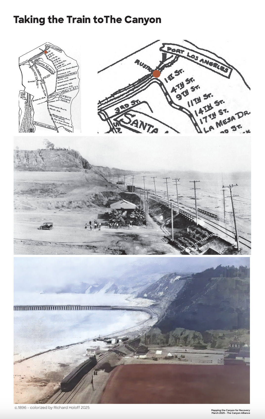
Maps illustrate the Canyon’s 1875 transition from Boca de Santa Monica to Old Santa Monica, after the City of Santa Monica was established. Photos, which have been colorized by Richard Holoff, simultaneously provide peeks into older versions of the Canyon.
In 1926, the Canyon was annexed by the City of Los Angeles, and a shoreline train brought visitors to the area. Later, more roads were built. In addition, eight miles of drainage channels, which contain the output of 30 miles of canyon waterways, including the flow from Rivas, Mandeville, Sullivan, Rustic, and Santa Monica canyons, were installed in an attempt to address potential floods. This system unfortunately failed in 1938, inspiring the city to build a new channel system.
The exhibit also depicts both the past and current fire dangers inherent in canyon living and provides a vision for addressing future disasters.
The exhibit’s introduction, written by The Canyon Alliance Director Doug Suisman, is below:
“The mountains are going to burn. The creeks are going to flood. The ground is going to shake. And the sea may even rise up in a wall.
“We live in a paradise, but one where disaster has always loomed: the terrible 1910 botulism poisoning of the Marquez family, the 1938 flooding of the canyon, the 1994 Northridge earthquake. And the man-made threats have been just as daunting: a proposed highway bridge across our canyons; a freeway from the Valley; off-shore oil drilling; over-scaled urban development.
“But none of these threats has come as close to cataclysm as the 2025 Palisades Fire. Through a combination of quick thinking, technology, heroism, and luck, our Canyon was just barely spared the catastrophic fate of our friends and neighbors in the Palisades. Next time, we may not be so lucky.
“So how do we preserve the Canyon’s cultural and historic legacy and its beautiful natural setting for our children and grandchildren? The proposition of The Canyon Alliance (a newly formed initiative of the Santa Monica Canyon Civic Association) is that we need to self-organize and self-govern with greater clarity and purpose than ever before. The disasters will continue to come as part of California’s natural cycles, but they will likely be worse due to man-made climate change. Are we ready for them?
CONFUSION AND CLARITY
“A key goal of the Alliance is first to turn confusion into clarity. Part of the charm of the Canyon is our mysterious character: our complex topography, our winding roads, our hidden staircases, our strange street numbering and naming system, our confusing use of the name Santa Monica when we are located entirely (and have been for one hundred years since 1925) within the City of Los Angeles.
“What can be charming and quirky on a typical day in paradise can be lethal in a disaster. Not understanding our own location and terrain makes it hard for us to convey critical information to first responders, firefighters, paramedics, emergency engineers. And when larger systems like power and water and flood control fail, our lack of clarity makes it hard to respond calmly to challenges during the storm.
MAPS
“The first step is good maps of the Canyon, of which we have had very few. And the ones available have often failed to clarify. First and foremost, our fascinating topography of cliffs, terraces, and creeks, once nearly bare and visible to the naked eye, has been so covered with housing and lush vegetation that it is almost impossible to discern in its totality. This exhibition highlights both historic maps and a group of recent maps, some produced during and after the fire. We hope they will help us all better understand the beauties and challenges of where we live.
NEIGHBORHOODS
“The second step is to understand our history and potential as a group of neighborhoods and as a unified Canyon community. The Canyon Alliance proposes that we have five distinct neighborhoods, identified by terrain and landmarks, which comprise the community of The Canyon. The terrain is defined not by just one but two distinct canyons: Rustic and Santa Monica. Each has an important creek, draining a collective 24 miles of water runoff from the Santa Monica Mountains. The two creeks converge at the mouth (“boca”) of the Canyon, an area so historically distinctive with its wide channel and steep cliffs that the vast Rancho de Boca de Santa Monica was named after it.
NEIGHBORHOOD ASSOCIATIONS
“Our five neighborhoods have had different forms of association at different times, but these volunteer organizations wax and wane as active residents come and go, and as the memories of past disasters fade. We need to have a strong neighborhood association in each of the five neighborhoods, and link them together in The Canyon Alliance so that we can act quickly, calmly, and wisely when the next disaster comes.
RESILIENCE
“This disaster preparedness network will also help us build long-term resilience: non-combustible materials, fire brigade, water tanks, pool pumps, earthquake preparedness, flood control. And in so doing, we can not only preserve the beauty that draws us here, but strengthen the extraordinary multi-generational bonds that make The Canyon community so special.
THE WORK
“Extraordinary work has already been done by many Canyon residents during and after the fire to bring us together. We have more to do. It’s good work, for us, for our families and descendants, for our Canyon, and for our city. Please take a look at the maps to find unexpected connections and possibilities. And help strengthen your new or existing neighborhood association so that together, we can launch The Canyon Alliance in 2025 and map the work that remains to be done.
The Canyon Alliance Director Doug Suisman’s remarks at the exhibit (courtesy Levi Langen)
A video tour of the exhibit (courtesy Karey Kirkpatrick)