

USC Canyon Soil Tests Show Low Levels of Lead
By Chad Billmyer
Special to Canyon News
(The Canyon News approach to coverage of environmental issues can be found here.)
The USC Department of Earth Sciences tested soil at two Canyon locations on Feb. 2 and found levels of lead deemed safe by Environmental Protection Agency (EPA) standards. A soil sample from Canyon Charter Elementary showed 14 parts per million (ppm) of lead. A sample from the intersection of Toulon Drive and Amalfi Drive returned a result of 82 ppm of lead.
In January of 2024, the EPA lowered screening levels for the first time in 30 years. A screening level is a concentration of a contaminant at or below which scientists and health professionals do not expect health effects to occur. The EPA lowered the screening level for lead in soil at residential properties from 400 ppm to 200 ppm. At residential properties with multiple sources of lead exposure, the EPA will generally use 100 ppm as the screening level. So far, the two soil test results in Santa Monica Canyon were below the EPA's most strict 100 ppm level.
“Every family and child, regardless of their zip code, deserves to live without worrying about the life-long health effects from exposure to lead pollution,” stated former EPA Administrator Michael S. Regan in a January 2024 release about the screening level change. “Today’s action ensures that the EPA uses the latest, best available science to protect children living and playing near sites contaminated by lead in soil."
California’s Office of Environmental Health Hazard Assessment follows slightly different soil screening levels for lead of 80 mg/kg (or ppm) in residential settings. The February 2nd sample from the intersection of Toulon Drive and Amalfi Drive showed 82 ppm of lead or just 2 ppm above the more strict 80 ppm threshold.
The Contaminant Level Evaluation and Analysis for Neighborhoods (CLEAN) organization will test the lead levels of soil from Santa Monica Canyon households for free. You can find instructions for collecting and submitting your sample at this link: https://publicexchange.usc.edu/la-wildfire-soil-testing/. As the test results come back, CLEAN posts the results on a map based on the collection location at this link: https://ngexplore.maps.arcgis.com/apps/mapviewer/index.html?webmap=882f0baf31a1453d9f4f8f560e62b3f1
Sources:
https://oehha.ca.gov/media/downloads/risk-assessment/fact-sheet/leadfactsheet.pdf
https://publicexchange.usc.edu/la-wildfire-soil-testing/
https://ngexplore.maps.arcgis.com/apps/mapviewer/index.html?webmap=882f0baf31a1453d9f4f8f560e62b3f1
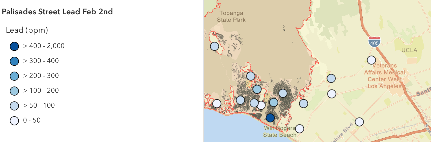
Palisades testing locations by the USC Department of Earth Sciences.